As the last borderline snow storm was unsuccessful here, we have another shot at potentially heavy accumulations of snow tonight for parts of NWOH and SEMI. Snow has already changed over from rain in most of lower Michigan, as colder temperatures work their way into the storm. Although the RUC/Rapid Refresh are not nearly as supportive, the HRRR shows the potential for a few inches of accumulation-potentially even more than that as snow changes over from rain late this evening.
Copious amounts of moisture are streaming in from the southern Ohio Valley, and precipitation is expected to stay in the area through the overnight hours. This rain will potentially turn to snow in Northwest Ohio this afternoon, even as early as 4:30-5:30 PM. This leaves heavy precipitation, likely some of it snow- in the area for several hours, leading to potential accumulations.
Again, this is another tough situation to forecast, as even during the storm, models have no handle on what's really going on. Due to the HRRR's continued consistency for this event, I will side for this for now. I currently expect a general 2-4" for most of NWOH and SEMI, although I could see those amounts completely busting. However, I think it is possible that someone receives over 5" in a localized area, but I don't expect that to be common.
Whatever happens, stay cautious on roadways this evening and be prepared for sudden changes in the weather. This is a very weird storm that could go either way. If we get snow, enjoy it. If not, don't be upset that we didn't. Until early this afternoon, nothing suggested a potential for any snow around here, and to see such a dramatic change is extremlely cool to see. Anyways, as Joe Bastardi says, "Enjoy the weather, because it's the only weather you got"
Showing posts with label heavy rain. Show all posts
Showing posts with label heavy rain. Show all posts
Monday, December 5, 2011
Tuesday, November 22, 2011
Thanksgiving Week Forecast
I originally planed to do a video forecast for this, but it was not working. So although a day late, here is the week ahead:
Today into early Wednesday will have some light to moderate rainfall.


Today into early Wednesday will have some light to moderate rainfall.

The heaviest rainfall will be along the I-70 corridor in Ohio, with less as you go further north and south. I have already picked up .2" of rain as I type this. Rain is expected to continue as the day progresses. As the low pressure system moves out of the Ohio Valley and towards the east coast, rainfall will slowly end, probably around the early morning tomorrow.
Thankfully, this rain will end early enough for a beautiful Thanksgiving day. It won't be very warm, with temperatures in the upper 40s to low 50s, but temperatures will rise a bit more on Friday, leading up to a nice start to the weekend.

However, this is where the tough part of the forecast will be. The global models are all predicting a storm to move up west of here into the midwest, leading to rising temperatures and rainfall during late Saturday. What happens after that is up for grabs. The GFS has consistently closed off the 500mb low, leading to a cold air shortage, with temperatures in the low 40s in Indiana/Ohio, while temperatures in northern Alabama ending colder than us! There are already significant differences within the first 72 hours between the GFS and other models, so unless other models start to do that, it remains an outlier at the time.
Another model to look at is the GGEM.

Yesterday, it also cut off the 500mb low, although in a different position than the GFS. Today's 12z run leaves the s/w in the west behind, leading to a northern stream only solution. However, it holds back some energy, and it eventually rounds the base of the trough, leading to a storm up eastern Ohio. This would be a decent snowfall event for western Ohio and parts of MI if taken verbatim. However, inconsistency remains a big issue.
The remaining models left are the UKMET and ECMWF. The UKMET has had some troubles in the long range, but is actually in second place, trailing the ECMWF on verification scores in the last month. Both the UKMET and ECMWF have a secondary low pressure system developing in the southeast US, but both have some differences in timing placement. The ECM showed over 6" of snow for some people in Ohio on yesterday's 12z run, than didn't do much on the 0z run. The 12z cycle is coming out soon, so I may go back and edit this post in an hour or so.
Hopefully by Thanksgiving we will have a better idea of what's going on. Right now I can't do much other than speculate that this could be a snow producer for some areas in the South/Central Great Lakes, but things could change rather rapidly. Until we get into the short range, the plot can only thicken. Stay tuned to the Ohio/Ontario/Michigan Weather Blog for More information on this storm and many others to come through the winter.
Happy Thanksgiving everyone!
Monday, October 17, 2011
Powerful Storm to Affect Great Lakes
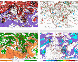
A powerful storm system is expected to move into the Great Lakes and Ohio Valley region this week. A low pressure system will develop in the southeast United States and move northeast, while strengthening rapidly. The NAM and GFS for the "peak" of the storm are shown below:


 As you can tell, this is a very strong system (Below 985mb). Now, as much as I hate to speculate, but if we were to see a storm track like that during winter, this would be a huge snow producer. Unfortunately for the winter lovers, this is still October, and this will all be rain. Surface temperatures are hovering in the mid to upper 40s for Northern OH, Southern MI and Ontario, so a cold rain is likely for more than 2 days. With a solid moisture transport from the Gulf of Mexico, this storm will produce copious amounts of rainfall across the area. Current model forecasts and the HPC suggest a potential for up to 4-5" of rain, especially in SEMI and NWOH. Depending on the amount of moisture and low pressure track, this could change considerably, but I'm confident the majority of the forecast region will receive more than 2" of rain from this system.
Not only will this system produce heavy rain, but high winds are also a bit of a concern. Surface winds are expecting to be around 20-30mph, with higher gusts. Winds just above the surface are at about 50mph, so winds that make it down to the surface will be quite strong.
Towards the end of the storm, I would not be surprised if there were some localized reports of snow/sleet/graupel, although the coldest upper level temperatures occur during the day. Still, temperatures columns are not favorable for any persistent snowfall or accumulations.
Looking ahead, it appears we will be fairly active over the next couple weeks, but nothing too significant. Stay tuned for updates on this storm and others.
Saturday, July 23, 2011
Scattered Thunderstorms Likely for the Weekend
Scattered Thunderstorms are likely across all of Ohio, southern Michigan and southern Ontario this weekend as a surface low in the plains slowly moves east. There is a slight chance for severe weather with these storms, which could contain damaging winds, and marginally severe hail. There is also a flash flood watch for northern Ohio after heavy rainfall yesterday.
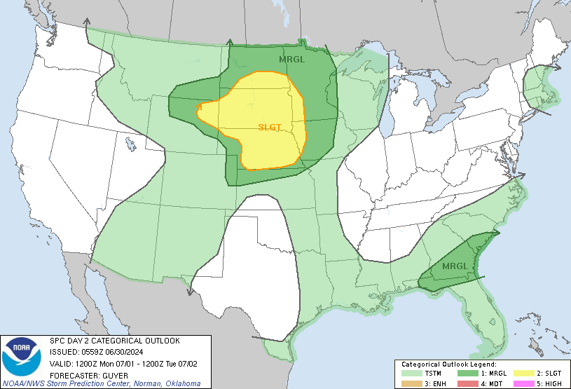
SPC Outlooks:
Today:
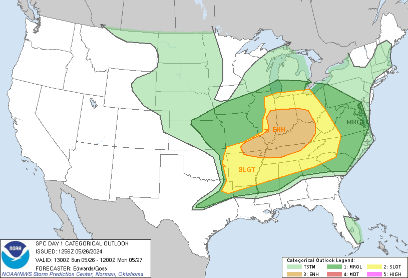 Tomorrow:
 Many of these storms will be slow moving due to weak upper level winds and low shear, so any storms that do develop may "sit" over a small area for a long period of time. However, a general storm motion of about 20-25mph will be more common.
Hot temperatures will also reside over the entire area once again, with temperatures reaching the low to mid 90s. Monday and Tuesday will be slightly cooler after this system moves out, but temps will rebound into the mid 90s again next week. Check the NWS for any heat warnings/advisories for your area.
Finally, I'm leaving for Colorado later today, and I'm not sure if or when I'll be able to check in again for the next week. I'll try to at least get on the chat a few times, but I cannot guarantee anything.
SPC Outlooks:
Today:
Hot temperatures will also reside over the entire area once again, with temperatures reaching the low to mid 90s. Monday and Tuesday will be slightly cooler after this system moves out, but temps will rebound into the mid 90s again next week. Check the NWS for any heat warnings/advisories for your area.
Finally, I'm leaving for Colorado later today, and I'm not sure if or when I'll be able to check in again for the next week. I'll try to at least get on the chat a few times, but I cannot guarantee anything.
Subscribe to:
Posts (Atom)