Tuesday, August 23, 2011
Severe Thunderstorms Possible Wednesday
The SPC in Norman has placed much of Ohio and southern Ontario (if extrapolated) in a Slight Risk of Severe storms. However, some rather significant severe weather is possible, depending on what happens during the morning hours tomorrow. The SPC expects thunderstorms to be in the area in the morning, which will weaken and eventually die off. This will allow for moderate destabilization with MLCAPE reaching about 3000J/kg by mid afternoon. This combined with shear around 35-40kts will allow for good storm organization to occur.
Storms are expected to be supercells as the develop during the mid afternoon, and eventually form into bowing segments. Some isolated tornadoes are possible, and you can see that clearly as the GFS is depicting large, curved hodographs:
I will be able to update at least once tomorrow to give a brief summary of what's going on, but I won't be able to do much other than that. Stay tuned to the Storm Prediction Center and the National Weather Service for more information and watches/warnings throughout the day tomorrow!
Saturday, July 23, 2011
Scattered Thunderstorms Likely for the Weekend
SPC Outlooks:
Today:
Tomorrow:
Many of these storms will be slow moving due to weak upper level winds and low shear, so any storms that do develop may "sit" over a small area for a long period of time. However, a general storm motion of about 20-25mph will be more common.
Hot temperatures will also reside over the entire area once again, with temperatures reaching the low to mid 90s. Monday and Tuesday will be slightly cooler after this system moves out, but temps will rebound into the mid 90s again next week. Check the NWS for any heat warnings/advisories for your area.
Finally, I'm leaving for Colorado later today, and I'm not sure if or when I'll be able to check in again for the next week. I'll try to at least get on the chat a few times, but I cannot guarantee anything.
Saturday, July 16, 2011
Excessive Heat Likely Next Week
This heat won't just be short lived. The Climate Prediction Center (CPC) has a 80% chance or greater of above average temperatures, for both the 6-10 Day, and 8-14 day outlooks:
Stay tuned for any updates regarding this and any other significant weather.
Monday, June 20, 2011
Slight Risk of Severe Storms Today
A dense fog advisory is also in effect for most of Northern Ohio until 9AM.
Sunday, June 19, 2011
3 Consecutive Days of Severe Thunderstorms Possible
Tomorrow could be an interesting day, with the warm front reaching the Ohio/Michigan border by the early afternoon. Shear should be quite high tomorrow, supporting storm organization, and some scattered storms capable of large hail and damaging winds will be likely. An isolated tornado can't be ruled out.
Tuesday, and Wednesday also have a lot of potential, but I'll cover those later tonight
Saturday, June 4, 2011
Severe Weather Today
Tuesday, May 31, 2011
More Severe Weather Today
Sunday, May 29, 2011
Slight/Moderate Risk of Severe Weather
Thursday, March 31, 2011
New Pattern to Emerge
This should be the warm-up that completely ends winter until next November. Here’s what we have going on with teleconnections. NAO (North Atlantic Oscillation on the left, Pacific-North American (PNA) on the right.

As you can see, the GEFS is showing a transition to a +NAO, and –PNA developing by mid to late next week. This would favor a trough in the western U.S., with a ridge in the eastern U.S., which would lead to warmer temperatures.


The GEFS shows the MJO moving into phase 6/7/8 in the next two weeks. When you look at 500mb composites taken from Raleighwx (Allan Huffman’s weather site), it correlates well with the NAO/PNA forecasts, of a ridge over the eastern U.S. This also is shown on the ECMWF, with temperatures skyrocketing by the Day 7 time period.
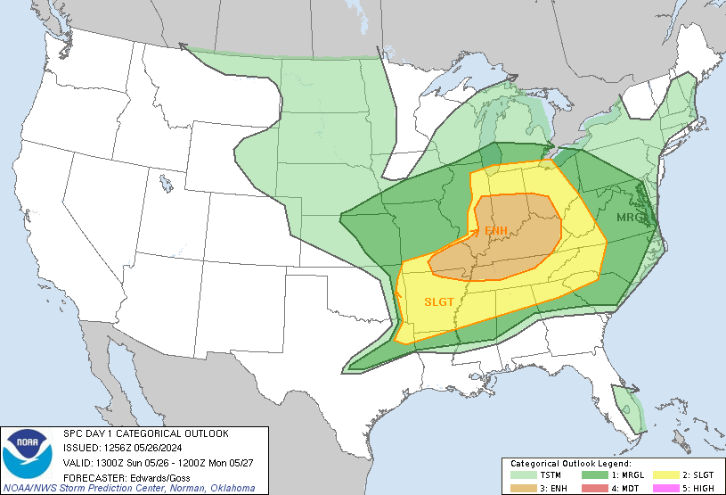
This warm-up is all tied to the storm before it, which will be a real rainmaker for someone and a severe weather threat for others. Where the low eventually does track will be crucial. Currently the ECMWF has this storm tracking from Chicago into southern Ontario, with severe weather possible as far north as the Ohio/Michigan border. South of the warm front will be a very moist, extremely sheared environment, which would indicate a good potential for severe weather. The SPC also outlined a general area for their Day 5 outlook, including parts of Ohio, and I think this has potential to be another Moderate Risk area day. All of the Great Lakes have a threat for flooding, with the amount of rain currently being forecasted by the ECMWF/GFS.
This is only the beginning of a very active spring, so keep checking back for updates.