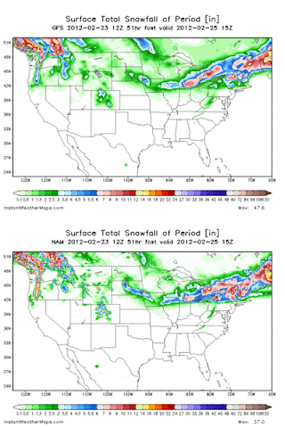
Well folks, this is one of the few times that I have absolutely no idea how significant this storm will be. Within 24 hours, this storm looked to be giving Detroit precip type issues, and NWOH was a solid rain. Now in the last 18 hours, I've had a continuous migraine. If I was healthy, I would have been on this chat, most likely freaking out a big (because forecasting means a lot to me). The model differences about this storm are incredible, and that is almost an understatement.
I have never seen such model discrepancies within 18 hours. Just take a look at these two images, one from the 12z NAM, one from the 12z GFS (this is a .gif file)
Now, let's look at the hi-res models. Here is the ARW and NMM 12z runs:
Now, both of those show all snow from a line north/west of Defiance to Fremont, and actually might be further south than that. Both would show about 2-6" north and west of Route 6, with 5-10" amounts in lower Michigan. Both show about 6-12" for almost all of Southern Ontario (which seems pretty likely).
Now both of those models contradict the GFS, and NAM to a certain point. The GFS showed nothing except for a small portion of Williams county. The NAM showed 3-6" for Route 6 and north, while the ARW/NMM would both be slightly south and higher with totals.
The model "fun" still isn't over with that, though. There are a variety of short term, hi-res models to view in the 18hr window before and during the storm. These are the RUC (to 18 and 24hr), the RR (or now called the RAP), and the HRRR (to 15hr). As you can imagine by the theme of this post, none of them agree with each other. The RAP shows nearly 2-4" by early morning Friday, with heavy snow still falling between Detroit and Bowling Green. This would likely show the most snow for anyone in the viewing area, given what it looks like at the end of its run. The model has also shown this very, very consistently over the past 4 hours. The RUC on the other hand, may be completely crazy. It shows zero for Detroit and even Toronto, which is incredibly unlikely. I've never trusted that model completely, nor do I now. Take a look at where it's snow zone is tomorrow:
If that actually happened, I would be left speechless. For now though, I'll just ignore it.
The final hi-res model is the HRRR. It's not completely in range yet, but the last run was the furthest south, snowiest solution I have seen from any model at any time for the region here in NWOH. I'll post a few images just so we can reminisce about it later.
That is actually the first time I've ever seen that model show 2-3" of snow IN ONE HOUR. I also do not like this solution, just because it seems unusually south. Either way, it would likely show 6-12" from BG to DTW... which may be a little high, and probably a little south of where it actually would be.
I'm not going to draw out a map for this event. I have little confidence in any map, specifically because of the lack of a clear cut solution from the computer models.
SNOWFALL for SELECTED CITIES:
Toledo- 1-4"
Detroit- 4-9"
Toronto: 2-4" (major, sharp left turn before it reaches the area.
Ann Arbor- 3-7"
There are several things to factor in:
How much of what falls will actually stick to the ground?
Where does it even snow?
Will night-time arrival help that much?


My family all the time say that I am killing my time here at net, except I know I am getting knowledge all the time by
ReplyDeletereading thes good posts.
Here is my page :: sexy chat
Hurrah, that's what I was exploring for, what a stuff! present here at this blog, thanks admin of this site.
ReplyDeleteAlso visit my homepage : click the next website page